GPS Hiker app for iPhone and iPad
4.2 (
192 ratings )
Travel
Navigation
Developer:
Jason Chiu
Free
Current version:
5.1, last update: 4 years ago
First release : 25 Mar 2012
App size: 7.82 Mb
GPS Hiker is a great and free application for outdoor activities. It supports GPS track logging, GPX file import/export and offline maps (Open Street Map, Open Cycle Map, Hike Bike and Custom Map Image) download and viewing. Camera, twitter and email features are integrated as well.
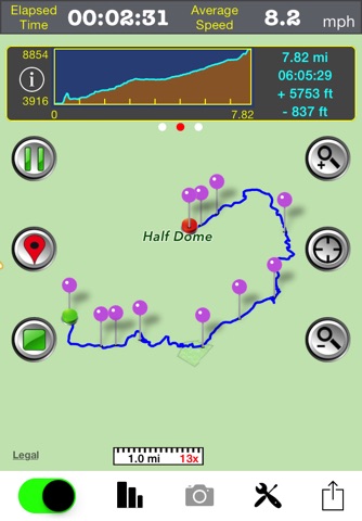
While in the outdoors and without cellular service, you can display currently logging tracks and previously logged tracks made by other parties simultaneously on the offline map to make sure you are on the right track. Photos taken during the logging session can be displayed on the map and saved for later use. You can also follow the previously logged track to assist your navigation and check the mileage and altitude information for reference.
GPS Hiker is proudly field-tested at Mission Peak, Fremont, CA, USA.
Features:
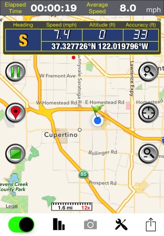
• GPS status (location, speed, heading, altitude) display.
• GPS logging & real-time trip information (time, distance, altitude gain/loss. ...) update.
• Tracks and marks are stored in the standard GPX format.
• You can manually add GPX files to the application via iTune File Sharing.
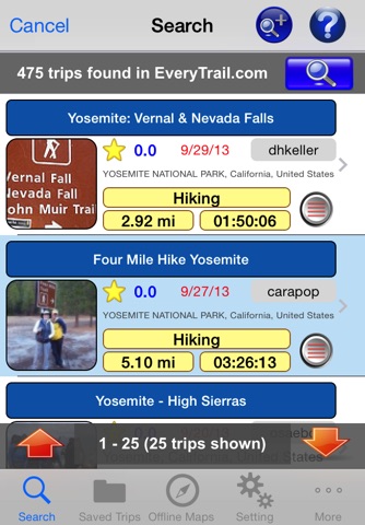
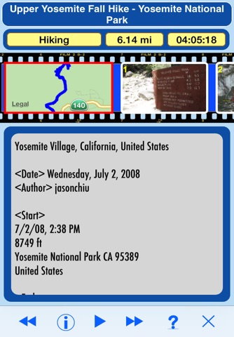
• Import GPX file you download from community websites and display its tracks and marks on map.
• Simultaneously display current track logged by yourself and imported track logged by others on map to make sure you are on the right track.
• Follow the track of the imported trip to assist your navigation.
• Photo Marks: photos taken during the trip will be displayed on the map. Title and description can be added to photos.
• Press-To-Find: long-press on the main map to find EveryTrail trips within the visual range of the map.
• Press-To-Mark: long-press anywhere on the main map to create marks for your trip.
• Multiple color and transparency options to display imported tracks on the map.
• Support online maps and offline maps (Open Street Map, Open Cycle Map, Hike Bike and custom map image).
• Trip Analysis allows you walk through the imported tracks in minutes and learn the related mileage, altitude and time information.
• Trail log to record your hiking activities.
• Interactive Altitude Profile Viewer.
• Universal Locate button to locate current location, last mark, current trip and imported trip.
• GPS switch allows user to switch off GPS, when not in use, to save battery power.
• Support WGS84-UTM, WGS84-DMS, WGS84-DEG, TWD67-TM2, TWD97-TM2 coordinate formats.
• Take geo-tagged photos with the built-in camera function.
• Email your trip to friends after the trip is done.
• TweetMark: Tweet your current location and last-taken photo (within 3 minutes) to Twitter.
• GPS tracking continues to work in the background while you listen to music or use another application.
• Support QR code to download trips.
Notice:
• This application may continue to use GPS in the background, which can dramatically decrease battery life.
• You need to connect your iOS device with iTunes and enable the Application File Sharing feature to add GPX files and custom map images to the application or to retrieve the GPX files for your trips.
• This application is not intended for precise navigation. Please use it with good judgement and at users own risk.
Pros and cons of GPS Hiker app for iPhone and iPad
GPS Hiker app good for
This app has been great for navigating in the forest. Maps are downloaded easily for off line use.
Developer is great at responding To questions.
Id be willing to pay for this app if there were a few more features such as a better review option for the saved trip and ability to specify zoom levels.
But for 0$, cant go wrong.
Great app, thanks.
After spending hours cobbling together a poor solution using for-fee apps I found GPS Hiker and it *rules*. The gpx download worked just as advertised via Itunes. In addition, it automatically caches map tiles near the gpx route so map data is available offline when in the backcountry away from internet. They dont even brag about doing this, it just works! Keep up the great work and many, many thanks.
Also, the other 2 reviews available for GPS Hiker when I downloaded it are ridiculous. One complains about GPS reliability, a function of your phone, not this app. The other didnt understand that it allows you to turn off GPS whenever you want.
Pretty good hike or walk tracking app. Can download (for free) Open Street Maps or Open Cycle Maps for offline use. Open Cycle Maps contain contour lines, useful for hikes in the hills. Shows all trip data. User interface could be a bit better; some options screens are a bit counterintuitive.
I installed this app and went for a hike without changing anything in presets. App was working fast and very accurately with all output data needed during and after the hike. Would be useful to have it in pro version with offline map downloaded on the phone.
Great, i like it!!:) Quite reach functionality with intuitive interface! Speed sensor is not so accurate, but its the problem of almost all GPS navigators.
Some bad moments
Ive used this app for the past few years and its nice that you can put your phone in airplane mode but about half of the time it will lose signal and not track you accurately. Great for a free app but the location services could use some tweaking.
Recently, AllTrails purchased EveryTrail, which this app was integrated with. When I opened this app today to prepare for an upcoming hike, it could no longer find the previous "Trips" saved by past users. The park we are going to is one of the most popular state parks in our state, so shouldve had some existing trails already saved. I then searched the Great Smoky Mountains, which weve used this app to hike in before, and it still wouldnt bring up past user Trips. I assume this is a result of AllTrails purchasing EveryTrail and AllTrails requires a yearly subscription to save offline maps. Being able to pull up saved trails created by past users allowed us to monitor our progress along those trails. Its nearly impossible to be able to do that for free. Without that capability, this app has become useless to us. I suppose it will still record your own progress when hiking, but there are a ton of apps out there that will do that.
even selecting other types of maps in the config page , it displays always the same google type map....
I just used this app to map a new Potential field trip for a geology course at my university. The app worked perfectly as described. I wish it could store pictures alongside mark points on the map so when you go back you can see the description and a picture. Keep up the good work and Im looking forward to the next version!
Although my "Location Services" is turned ON, starting this App gives me an error message to turn them ON - iPhone 4.
I thought it would be garbage since it was free. I would gladly pay $15 or more now that I have used it. You can import routes, drop waypoints, and it tracks everything from altitude, pace, etc. if you want to capture you trail runs or learn new routes, this app is for you.